Tower Mountain and Dixie Butte Lookouts and Crockets Knob Fire - Plus Indian Rock
- Wizard of Wandering
- Oct 1, 2022
- 4 min read
Updated: Oct 3, 2022

Another trip to more Oregon fire lookouts!
We planned to visit several more Oregon fire lookouts on this day trip, starting with Indian Rock and then Tower Mountain. But this was in the middle of fire season so we knew our plans may need to change - and they did!
Our Original Trip

Indian Rock Lookout
Coordinates: 44.756792, -118.691747
Elevation: 7,353 feet
On our way to Indian Rock lookout, we were met by the Grant County Sheriff, Todd McKinley, who re-directed our route and suggested we visit Dixie Butte because we wouldn't be able to reach Indian Rock Lookout due to the Crockets Knob fire. Close to where the sheriff stopped us, we saw one of the fire-fighting helicopters scooping up water to carry to the fire.
Indian Rock was off our list but courtesy of Eric Hendrickson and the Crockets Knob Fire Facebook site @CrocketsKnobFire · Public & Government Service, we do have images of Indian Rock Lookout wrapped in foil to protect it from fire.
Indian Rock Lookout was established in 1929 with a cupola cabin. The current R-6 flat cab was built in 1957 and is staffed every summer.
To reach Indian Rock, travel east on the Middle Fork of John Day River Road from State Highway 395 turning at Ritter Junction or West from State Highway 7, turning at Austin Junction. At milepost 14 on Middle Fork Road, turn north on Road 45 and go approximately 10 miles to the 4500/537 junction that will take you to Indian Rock Lookout.
Geocache: Indian Rock GCGEAD
Coordinates: 44.755683, -118.691750
The view from where this cache is located is absolutely amazing! Or, so we heard - since we weren't able to travel here.
Repeater: Beaver Mountain 145.270 W7NYW
Repeater: Tower Mountain 145.290 W7NEO
Repeater: Sheep Mountain 145.430 K7AA
Next we were off to Dixie Butte.
Dixie Butte

Coordinates: 44.5829634°N, -118.6264956°W
Elevation: 7,592 feet
Dixie Butte is located approximately 27 miles northeast of John Day. Most of the road is paved (Highway 26). At the top of Dixie Summit Pass, turn north onto road #2610 and a hard right on the first dirt road on the left. If you pass the rope tow at the ski area, you are on the correct road. From here, you should have a high clearance vehicle and good traction tire. The last 1.2 or so miles is narrow, steep and rough. Once you get to Dixie Butte, the road around the lookout is gated and locked, so you will need to walk up to the lookout. As always, be respectful and don't go up on the lookout deck without permission.
Geocache: Lookout Dixie! LOT GCK8CK
44.582200 -118.627783
Repeater: Sheep Mountain 145.430 K7AA
Repeater: Beaver Mountain 145.270 W7NYW
Repeater: Tower Mountain 145.290 W7NEO
Repeater: Fall Mountain 147.220 N7LZM
After Dixie Butte, we headed to our overnight camping spot near Dale, Oregon. Thanks to our iKamper rooftop tent on our Jeep Wrangler from Larry Miller in Boise, setting up camp is quick and easy. Once in camp, we use our Jackery generator (with solar panels) to re-charge everything from the Autel Evo II Pro drone batteries to our cell phones.


The next morning, we packed up camp to go find the Tower Mountain Lookout.
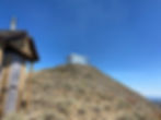
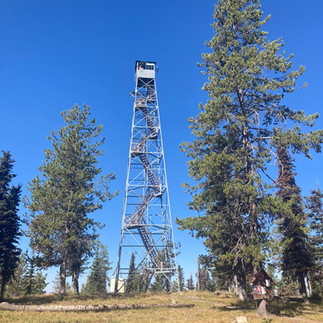
Tower Mountain Lookout
Coordinates: 45.054309, -118.568922
Elevation: 6,850 feet
Originally called Lookout Mountain, the name was changed to Tower Mountain in 1925 to avoid confusion with another Lookout Mountain nearby. The site is on the National Historic Lookout Register, and the lookout is staffed every summer.

And sometimes we find unusual historical memorabilia - this from the old Tower Mountain outhouse: "Remembering those who have gone before..."

More History of Tower Mountain
Mike Duffy, staffing Tower Mountain the summer of 2022 when we were there, told us the following:
"In 1914 Walter Alison and Bun Moore built a wood tower on what would later be known as the highest elevation in Umatilla County: Tower Mountain. Early lookout staffers lived in tent camping and had to go chasing their own smokes when they spotted a fire. In the 1930’s, the wood tower was replaced with an Aeromotor 7x7 type steel tower which remains in service today. Also in service is the 1934 Model Osbourne Firefinder sighting device used for establishing azimuths towards a detected smoke.
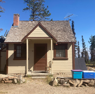
For years, communication was managed over a thread of miles and miles of No. 9 wire, strung from the office in Ukiah to Tower Mountain and the other remote stations. Eventually, radios were used, and upgrades to those systems are still ongoing. Ray Kresek, in his book "Fire Lookouts of the Northwest,” tells the story of a lookout man who, for whatever reason, burnt the cabin living quarters and ran off. As a remedy, Ranger District staff hauled a cabin up from Lucky Strike Lookout which was being abandoned in 1945. Until the 1990’s, the cabin was heated with a pot-bellied wood stove that was used for cooking and heating water. The cabin today, the same single room building, has propane heat, refrigerator and an apartment sized range. Small solar and battery systems are used for electrical power.
It is 106 stairs up to the Tower cab; about 80’ to the floor. Site elevation is 6,850 feet. Access is by 8 to 12 miles (depending on your route) of single lane dirt road. When the lookout staff on duty is not too busy, visitors are welcome to climb the lookout for a visit and to share in the amazing vista. On a clear day, Mt Rainier – 200 miles northwest – is plainly visible."


Geocache: Johnny Cache GCA8D1
45.054550, -118.568233
www.Geocaching.com : (quote)
Quote from the geocaching site: "Once you have reached the coordinates, pace 365 feet on compass bearing 215 degrees.
HINT: ‘Look Out’ Smokey’s watching"
Repeater: Tower Mountain 145.290 W7NEO
Getting There
STARTING POINT: Boise
ROUND TRIP: Two days
ROAD SURFACE: Paved and dirt roads; all-wheel drive is required for some of the roads to the lookouts.
WHEN ACCESSIBLE: Summer
FEES: None
RECOMMENDED VEHICLES: All-wheel drive or 4WD
PET FRIENDLY: On leash at fire lookouts, but only with permission of the staff at each lookout site
WHEN WE WENT: First week of September
I'm Here - Now What?
Bring your smart phone or a GPS
Bring your kids, if you have any!
Bring your dog
Hiking - wear good walking shoes
Biking
Photography
Wildlife and plant viewing
Picnicking
Camping
Fishing
And a sense of adventure!