
Scott Mountain Lookout
- Wizard of Wandering
- Jan 14, 2023
- 3 min read

A rugged and wild area with impressive views!
Here is a great description of Scott Mountain and a story to go along with it in this quote from Bruce Lang who works as the Scott Mountain Fire Lookout for the Forest Service in the Boise National Forest:
"Established in 1934, Scott Mountain Lookout sits at 8,215 feet on a mountain of granite! The name “Scott” came from a man who established a trail to move cattle from one location to another in the area below the lookout. His real name is William, but he was Scottish which is where the name Scott came in to play.
Serving as a key lookout for the USDA Forest Service, overseeing Crouch, Garden Valley and the numerous families camping about the Deadwood reservoir and Boise National Forest. As a popular drive-to lookout, Scott Mountain generates countless visitors throughout the season. Many families learn about the fire-finder, what a fire lookout’s day entails, and a well placed fire prevention message! The best part is handing out Smokey swag to the kids and seeing big smiles!
Granite Basin to the west and Onion Valley to the north give way to endless mountain ranges. Highlighting the views are the Sawtooth Mountains to the east, or Squaw Butte in Emmett to the west. So pack up the family and some lunch, take a slow ride up to a magical place called Scott Mountain Lookout. Warning, the sunrise and sunsets are spectacular!"
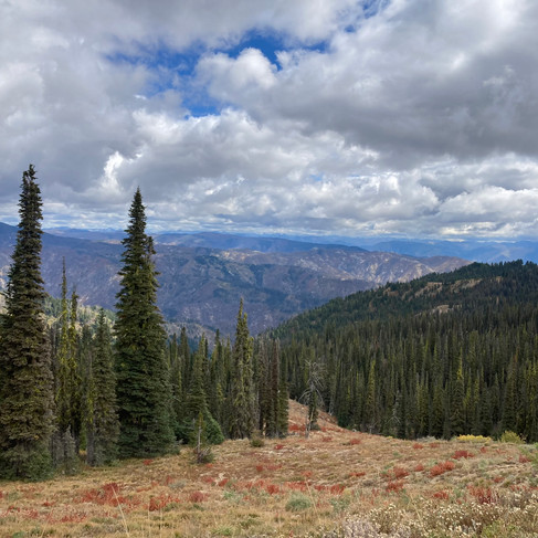
And here is a glimpse of what you see from Scott Mountain Lookout!
Scott Mountain Lookout is an active fire lookout at the south end of the Log Mountain/Deadwood Ridge Divide. This area is rugged and wild, with rough, granite outcroppings looking out at surrounding peaks that range from 7,800 to 8,200 feet in elevation.

The lookout tower sits at the top of the summit on an unusual 28'x28' stone foundation. The L-4 cab was built in 1934 and replaced the 12'x12' log cabin built in 1920. It was added to the National Historic Lookout Register in 2011. This historic lookout is still occupied during fire season to watch for fires in the surrounding area.


Access is limited to the summer season, and maybe into early Fall. To reach Scott Mountain, take Deadwood Reservoir Road approximately 10 miles from the pavement on Highway 17 to the junction with the road to Scott Mountain.


From the junction, it's a little over 4 miles to the summit on Forest Road 555 which is a bit of a rough road - but with great views! A 4WD or AWD vehicle is recommended for this trip.


Getting There
There are multiple ways to get to Scott Mountain Lookout. If you use an online mapping tool, the most likely route is the one directly below. We took a different route for a couple of reasons. Our plan was to visit three lookouts: Deadwood, Scott Mountain and Sunset Mountain. The other reason for our route is because we live on the far east side of Boise and heading up Highway 21 is closer for us. The route we did take is shown on the second map below.
The route we took:

STARTING POINT: Boise
DISTANCE FROM STARTING POINT: One way from home was approximately 80 miles
TIME TO REACH: About 2-1/2 hours
ROAD SURFACE: Dirt road up to the lookout
WHEN ACCESSIBLE: Summer, Early Fall
FEES: None
RECOMMENDED VEHICLES: 4WD or AWD with high clearance
PET FRIENDLY: On leash recommended, but off leash is allowed
WHEN WE WENT: Early Fall
Repeater: Pilot Peak 145.310 KA7ERV
Repeater: Snowbank Mountain 146.620 W7VOI
I'm Here - Now What?
Bring your smart phone or a GPS
Bring your kids!
Bring your dog
Hiking
Biking
Photography
Wildlife and plant viewing
Picnicking
Geocache: Scott Mountain Lookout GC1E4CK
44.181600, -115.789733
HINT: Under rock next to trail leading away from parking area and the lookout
To learn more about geocaching and the app, go to www.geocaching.com.