Leslie Gulch, Jordan Valley
- Wizard of Wandering
- Mar 21, 2021
- 3 min read
Updated: Aug 14, 2024

High desert drama with panoramic views of stone and sage
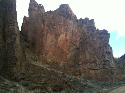
Leslie Gulch is a canyon in Malheur County, Oregon, with abundant and striking rock formations, on the east side of Owyhee Lake, a reservoir on the Owyhee River. The gulch was named after a local rancher, Hiram E. Leslie, who was hit by lightning here in 1882. Previously it had been called "Dugout Gulch."
The road to Leslie Gulch is gravel/dirt and the travel speed is between 10 and 15 mph for much of the way...but, the trip is worth the slow drive! Bring a picnic and enjoy the spires, cliffs, rock formations, colors that you will see along the way!
LATITUDE/LONGITUDE: 43.321820, -117.323800
STARTING POINT: Boise
DISTANCE FROM STARTING POINT: 76 miles (one way)
TIME TO REACH: Approximately 3 hours 30 minutes (one way)
ROAD SURFACE: Paved and gravel/dirt
WHEN ACCESSIBLE: Year round; best access May - October
FEES: No
RECOMMENDED VEHICLES: A high clearance, four-wheel drive vehicle is recommended; accessibility is dependent on road conditions.
PET FRIENDLY: Yes
WHEN WE WENT: Summer
TRAILHEADS: Hiking trails are throughout the area; try the trail from the parking area or if you have time, enjoy a hike on the Upper Leslie Gulch trail. Remember that hiking off the trails is not recommended because of the sensitive nature of the soils in the area.
CAMPGROUNDS: Picnic sites and 12 campsites are down near the reservoir and restrooms are available. There is no drinking water, so remember to bring your own water.
SITE CONTACT INFO:
BLM Vale District office for facilities rental information, current road access conditions, and any seasonal fire closure restrictions. 541-473-3144
CAUTIONS: Be prepared for ticks and rattlesnakes, and extreme weather conditions.

Getting There
From Boise:
Take I-84 west to Exit 33A, head right on the ramp for ID-55 South toward Marsing/Nampa. Turn right onto ID-55. Turn left onto US-95 South / High 95. Keep right to stay on US-95 South. Go approximately 12.9 miles, turn right on McBride Creek Road; In about 2.5 miles the road name changes to McBride Road as you are entering Oregon. Go about 6.2 miles and make a sharp right onto Succor Creek Road. After 1.8 miles, turn left onto Leslie Gulch Road and travel approximately 14.1 miles to Leslie Gulch. The last intersection before your destination is Succor Creek Road.
CAUTIONS: When you travel in the Owyhee Canyonlands you need to be prepared and self-sufficient. You will not find services when you leave the paved roads. Have a full gas tank and even consider carrying a spare gas can.
Driving conditions can be challenging. Pay attention to vehicle clearance and four-wheel drive recommendations. Even a little rainfall makes the roads here slippery, which will clog wheel wells with mud and limit travel.
I'm Here - Now What?
Most of the area is part of a Wilderness Study Area, so please be respectful of the environment while you are enjoying the beauty of this remarkable place!
The most amazing features of Leslie Gulch are the colorful, towering rock formations that have been carved by nature over the years since the ash and rock fragments were deposited here from volcanic eruptions millions of years ago.
Motorized vehicles and bicycles are limited to existing roads and parking areas.
Fishing
Photography
Wildlife and plant viewing
Boating - a concrete boat ramp provides access to the Owyhee Reservoir for small water craft.
Rafting/floating
Camping (limited to 14 days)
Picnicking
Hiking
Biking
The collection of vegetation, rock materials and firewood not permitted.


Comments